On the first weekend of October GARS members participated on a historical trek with our parental organization Harmaasudet. It took place in Suomussalmi, northeastern Finland, and followed so-called Viena Route which is an ancient trade route from Baltic Sea to White Sea, through Finnish region of Kainuu and Russian region of Viena Karelia. In the 17th century the most important trade good on the route was salt, that was imported from the trading town of Kemi on the shore of White Sea (not to be confused with other Kemi in Finland) where local Karelian population had salt-extraction industry. Finland had no natural salt resources as the Baltic Sea is too low-salted for extraction.

Dead route marker tree on Aittojärvi ridge
Transportation on the Viena route was historically mostly done by small boats, following rivers and lakes and on few places hauling the boats overland. Old walking paths follow the same route on high ridges, and for a modern trekker walking on them is of course most accessible way of experiencing the route. During the last decades the paths have been investigated archaeologically and one of the many alternative paths has been renovated for trekkers. Route is often very easy to follow becouse it is constantly lined by pilkkapuu axe-marked trees, some of them very old, an centuries-old way of making route markers. On some places, however, modern roads and heavy logging have destroyed stretches of the route.

The oldest route marker tree in Finland – from year 1682
We did a two-day historical trek on the renovated route and also on some bypaths: the marked Itärajan retkeilyreitti -path that runs alongside the eastern border of Finland, and on smaller border guards’ path. Like always on our historical treks, everyone attending did it in a historical kit: this time we had mixed time periods, so some of us went in medieval kit, some preferred 17th century and some wore early 20th century clothes. Obviusly we walked only the Finnish side of the route: after the Finnish independence in 1917 the Viena Route hasn’t been in cross-border use, at least in a non-military way.

Paths typically follow high ridges
One of the oldest descriptions about the Finnish side of the Viena Route can be found in a 1650 map made by Claes Claesson, a cartographer of Count Per Brahe, general governor over Finland. A border crossing point in Vuokinlatva, between Korpijärvi and Latvajärvi is marked on the map.
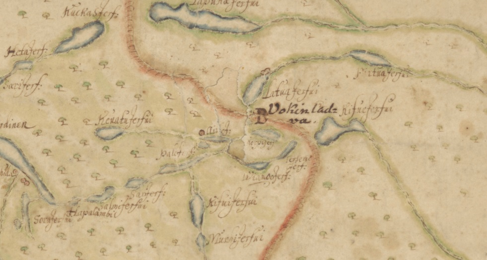
Detail of a 1650 map of Kajaanipori (modern Kainuu) region by Claes Claessonin. University of Jyväskylä. You can download the full map.
On the Claesson map you can find the Finnish names for many of the lakes that also the trekking route follows: Kevättijärvi, Palojärvi, Aittojärvi ja Viianginjärvi. Below is a modern map with the same lakes and the main 30 kilometer long Viena trekking route marked with black line.

Origin of the map http://kulttuuriperintoinventointi.blogspot.com/
Also on the Claesson map there is a single red circle by the Aittojärvi lake. That means a farm or a house, but there aren’t any nowadays. The area is now called Isoautio, “big deserted place”, and archaeologists have found remains of a 17th century farm from there. From the tax documents of the era we know that peasant Antti Hyry owned the Aittojärvi farm back then, and becouse there still is a farm called Hyry few kilometers east, it is possible that the older farm was simply moved into a new place.

Porrasjoki river
Still continuing in the world of maps, there is also a slightly older source for the place names on the Russian stretch of the Viena Route: the map of Northern Russia by Isaac Massa, from year 1633. Below is a detail of it: in the left you can see the Gulf of Bothnia and city of Oulu (Uleåborg), then straight to east the big lake Oulu (Ula Tresk) and the Cajana castle in Eastern Finland. On the right there is the White sea and on it’s shore the town of Kemi. Many place names in the Russian side of the border are on Karelian (finnic) language, or in a mixture of Karelian and Swedish: Maanselkeby comes from Karelian Maanselkä (“Land’s back”: water divide) and swedish by, village. It is probably modern Latvajärvi on the Russian side of the border, just east from the Finnish village of Raate. “Paiersvi Tresk” means Pääjärvi-träsk, literally Main lake-lake.

Detail of a map Karta Rossii I. Massy 1633, The New York Public Library digital collections. You can download the full map
Author of the map Isaac Massa was a Dutch trader, writer and Russia expert who visited Viena Karelia himself. For many history enthusiasts he is anyways probably best known from this painting by Frans Hals

Wedding portrait of Isaac Massa and Beatrix van der Laan, Frans Hals, Rijksmuseum

Crossing the Kaartosuo bog

Border guards’s path between Hangaslammit lakes