On Viena Route

On the first weekend of October GARS members participated on a historical trek with our parental organization Harmaasudet. It took place in Suomussalmi, northeastern Finland, and followed so-called Viena Route which is an ancient trade route from Baltic Sea to White Sea, through Finnish region of Kainuu and Russian region of Viena Karelia. In the 17th century the most important trade good on the route was salt, that was imported from the trading town of Kemi on the shore of White Sea (not to be confused with other Kemi in Finland) where local Karelian population had salt-extraction industry. Finland had no natural salt resources as the Baltic Sea is too low-salted for extraction.

Dead route marker tree on Aittojärvi ridge

Transportation on the Viena route was historically mostly done by small boats, following rivers and lakes and on few places hauling the boats overland. Old walking paths follow the same route on high ridges, and for a modern trekker walking on them is of course most accessible way of experiencing the route. During the last decades the paths have been investigated archaeologically and one of the many alternative paths has been renovated for trekkers. Route is often very easy to follow becouse it is constantly lined by pilkkapuu axe-marked trees, some of them very old, an centuries-old way of making route markers. On some places, however, modern roads and heavy logging have destroyed stretches of the route.

The oldest route marker tree in Finland – from year 1682

We did a two-day historical trek on the renovated route and also on some bypaths: the marked Itärajan retkeilyreitti -path that runs alongside the eastern border of Finland, and on smaller border guards’ path. Like always on our historical treks, everyone attending did it in a historical kit: this time we had mixed time periods, so some of us went in medieval kit, some preferred 17th century and some wore early 20th century clothes. Obviusly we walked only the Finnish side of the route: after the Finnish independence in 1917 the Viena Route hasn’t been in cross-border use, at least in a non-military way.

Paths typically follow high ridges

One of the oldest descriptions about the Finnish side of the Viena Route can be found in a 1650 map made by Claes Claesson, a cartographer of Count Per Brahe, general governor over Finland. A border crossing point in Vuokinlatva, between Korpijärvi and Latvajärvi is marked on the map.
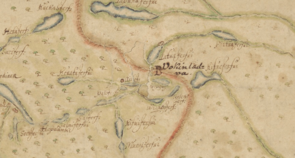
Detail of a 1650 map of Kajaanipori (modern Kainuu) region by Claes Claessonin. University of Jyväskylä. You can download the full map.

On the Claesson map you can find the Finnish names for many of the lakes that also the trekking route follows: Kevättijärvi, Palojärvi, Aittojärvi ja Viianginjärvi. Below is a modern map with the same lakes and the main 30 kilometer long Viena trekking route marked with black line.

Origin of the map http://kulttuuriperintoinventointi.blogspot.com/

Also on the Claesson map there is a single red circle by the Aittojärvi lake. That means a farm or a house, but there aren’t any nowadays. The area is now called Isoautio, “big deserted place”, and archaeologists have found remains of a 17th century farm from there. From the tax documents of the era we know that peasant Antti Hyry owned the Aittojärvi farm back then, and becouse there still is a farm called Hyry few kilometers east, it is possible that the older farm was simply moved into a new place.

Porrasjoki river

Still continuing in the world of maps, there is also a slightly older source for the place names on the Russian stretch of the Viena Route: the map of Northern Russia by Isaac Massa, from year 1633. Below is a detail of it: in the left you can see the Gulf of Bothnia and city of Oulu (Uleåborg), then straight to east the big lake Oulu (Ula Tresk) and the Cajana castle in Eastern Finland. On the right there is the White sea and on it’s shore the town of Kemi. Many place names in the Russian side of the border are on Karelian (finnic) language, or in a mixture of Karelian and Swedish: Maanselkeby comes from Karelian Maanselkä (“Land’s back”: water divide) and swedish by, village. It is probably modern Latvajärvi on the Russian side of the border, just east from the Finnish village of Raate. “Paiersvi Tresk” means Pääjärvi-träsk, literally Main lake-lake.

Detail of a map Karta Rossii I. Massy 1633, The New York Public Library digital collections. You can download the full map

Author of the map Isaac Massa was a Dutch trader, writer and Russia expert who visited Viena Karelia himself. For many history enthusiasts he is anyways probably best known from this painting by Frans Hals

Wedding portrait of Isaac Massa and Beatrix van der Laan, Frans Hals, Rijksmuseum

Crossing the Kaartosuo bog

Border guards’s path between Hangaslammit lakes


Vienan reitillä

GARSin jäseniä oli lokakuun ensimmäisenä viikonloppuna emo-organisaatio Harmaasusien järjestämällä historianelävöitysvaelluksella Suomussalmella Vienan reitillä, muinaisella kauppareitillä joka kulki Kainuusta Vienaan, Perämereltä Vienanmerelle. 1600-luvulla tärkein kauppatuote joka reitillä kulki oli suola, jota tuotiin Vienan Kemin suurelta kauppapaikalta Suomeen. Suolahan on Suomessa ollut aina tuontituote, vähäsuolaisesta Itämerestä kun ei saa sitä erotettua: vienankarjalaiset olivat sen sijaan kehittäneet tehokkaat menetelmät suolantuotantoon. Vienan Kemi oli suolakaupan suurin keskus Vienanmerellä.

Keloontunut pilkkapuu Aittojärven harjulla

Kaupankäyntitarkoituksessa reitillä kuljettiin entisinä aikoina ennen kaikkea vesireittejä, mutta jokia ja järvieä seurailevat myös vanhat harjupolut joita nykyajan retkeilijä voi vaivattomasti käyttää. Viime vuosikymmeninä polkuja on inventoitu arkeologisesti ja yksi monista vaihtoehtoisista on kunnostettu Vienan reitti-retkeilypoluksi. Polkua voi monin paikoin helposti seurata alkuperäisellä reitillään ikivanhojen pilkkapuiden viitoittamana, eikä minkäänlaisia nykyaikaisia reittimerkkejä edes tarvita, toisissa paikoissa vanhat polut ovat kadonneet maanteiden ja metsätalouden jälkien alle.

Suomen vanhin reittimerkkipuu v.1682

Me teimme kaksipäiväisen historiallisen vaelluksen sekä kunnostetulla Vienan reitillä että siitä erkanevilla vaihtoehtoisilla poluilla: Itärajan retkeilyreitillä sekä rajavyöhykkeen pinnassa kulkevalla rajavartioiden polulla. Vaelluksella oli edustettuna useat eri aikakaudet Vienan reitin historian varrelta: osallistujista osa vaelsi keskiaikaisissa varusteissa, osa 1600-luvun ja osa 1900-luvun alun puvuissa. Vaelsimme pelkästään Suomen puolella reittiä, eikä Vienan reitti ole enää Suomen itsenäistymisen 1917 jälkeen ole ollut rajat ylittävän kanssakäymisen käytössä, rauhanomaisissa merkeissä ainakaan.

Harjupolulla

Yksi vanhimmista kartalle piirrettyjä kuvauksia Vienan reitin Suomen puoleisesta osasta löytyy Pietari Brahen hovikartoittajan Claes Claessonin v. 1650 julkaistusta Kajaaniporin läänin kartasta, johon on merkitty rajanylityspaikka Vuokinlatvassa Korpijärven ja Latvajärven välillä.

Yksityiskohta Claes Claessonin kartasta Kajaaniporin läänistä vuodelta 1650, Jyväskylän yliopisto. Koko kartta ladattavissa 

Claessonin kartasta löytyvät suomenkielisillä nimillään myös monet niistä järvistä joita nykyinen Vienan reitin retkeilypolku seuraa: mm. Kevättijärvi, Palojärvi, Aittojärvi ja Viianginjärvi. Vertailuna nykyaikainen kartta alueesta, kartalle merkitty mustalla pääreitti.

Kartan lähde http://kulttuuriperintoinventointi.blogspot.com/

Mielenkiintoinen lisätieto Claessonin kartassa on Aittojärven pohjoisrannalle merkitty asutustilaa tarkoittava pyöreä merkki. Nykyään tällä paikalla ei ole asutusta mutta se tunnetaan nimellä Isoautio, minkä voi olettaa viittaavaan merkittävään autioituneeseen tilaan.
Aittojärven rannalta onkin tutkimuksissa löytynyt mahdollinen 1600-luvun asutusjäännös. Tämä Aittojärven tila jonka 1650-luvulla omisti talopoika Antti Hyry olisi sitten mahdollisesti myöhemmin siirtynyt muutaman kilometrin itäänpäin, mistä Malahviantien varresta löytyy nykyään Hyry-niminen tila. Lisätietoa kohteen arkeologisesta tarkastuskertomuksesta

Porrasjoki

Ja jos jatketaan karttojen maailmassa, löytyy Vienan reitin Venäjän puoleisista osista tietoa jo hieman vanhemmasta lähteestä: Isaac Massan Pohjois-Venäjän kartasta vuodelta 1633. Kartassa vasemmalla on Perämeri ja Oulu, siitä itäänpäin löytyvät Oulujärvi ja Kajaaninlinna, ja oikealla Vienanmeri ja sen rannalla Vienan Kemi. Monet paikannimet Vienassa ovat karjalankielisiä tai sekoituksia karjalasta ja ruotsista: esimerkiksi Maanselkeby sekä Paiersvi Tresk, eli Maanselän kylä (Vienan reitin pohjoisin piste, nykyisen Latvajärven seudulla) ja Pääjärvi.

Yksityiskohta kartasta Karta Rossii I. Massy 1633, The New York Public Library digital collections. Koko kartta ladattavissa

Kartan tekijä Isaac Massa oli hollantilainen kauppias, kirjailija ja Venäjän tuntija. Hän on monille historianharrastajille kuitenkin ehkä tunnetuin tästä Frans Halsin maalauksesta

Isaac Massan ja Beatrix van der Laanin häämuotokuva, Frans Hals, Rijksmuseum

Kaartosuo Itärajan retkeilyreitillä

Rajamiesten polku Hangaslammilla

von Essen’s infantry regiment in 1626-1628

Story continues from previous post about the battle of Weichselmünde 1628. Now we take closer look at the Finnish infantry present at that battle. The sources are the same, Hakkapeliittain Historia II by Arvi Korhonen (1942) and Pohjan Prikaatin Historia by Stig Roudasmaa (1984).

Alexander von Essen’s infantry regiment was formed in 1626 as a result of king’s military reforms: in Finland, three large landsregements were divided into smaller, more numerous regiments, themselves organized after new Dutch model. The new länsregements were clearly provincial in character, even though during Gustavus Adolphus’s time they were not yet officially named after their provinces but after their colonel. The von Essen’s regiment was reqruited from Ostrobothnian province and later came to be called the Ostrobothnian Infantry Regiment, with province’s coat of arms in its flag.

Ostrobothnia province (Pohjanmaa in Finnish, Österbotten in Swedish) is in northwestern part of Finland, the eastern shore of the Bothnian Gulf: coastline of fishermen’s villages on the islands and small towns trading furs and tar, and flat inland part with wealthy and rebellious peasantry.

Botnia Orientalis in Olaus Magnus’s Carta Marina from 1539. ”They build ships here” written near Närpes.

During 17th century, not much unlike today, the coastal villages of Pohjanmaa were predominantly Swedish-speaking and the inland Finnish-speaking. So also the von Essen’s regiment was bilingual with some companies, like Colonel’s and Major’s, drawn entirely from coastal villages and thus Swedish-speaking in character, while von Falkenberg’s (later Hume’s) company was made of men from the Finnish-speaking areas like Ilmajoki and Laihia. Lichton’s regiment was drawn from extreme north part of the province, Kemi and Ii areast that reached far into the wilderness that is modern Lapland.

And to add to two native languages, there were the multinational officers, with names like Suther, Lichton and Hume (Scots) and Schultz and von Falkenberg (Germans). There were also several native Swedish officers and some Finns too. The commander of the regiment, Alexander von Essen, was himself a Baltic German from Estonia. Before becoming commander of the Ostrobothnian regiment at the age of 31 years, he had already served in Prince of Orange’s lifeguard and in Venetian, Spanish and Polish armies.

Link to colonel von Essen’s biography

The regiment was first gathered in one place at 27.7.1626 in the city of Turku, Finland. There were 1123 men waiting for ships to take them to Prussia and to war. Equipment was lacking, most of the men were dressed in their own clothes, in Finnish peasant style that was not suitable for parades. Many were unarmed. In the last minute the regiment received a shipment of hundreds of muskets and pikes and several hundred meters of cloth for new uniforms. Also new flags were received, 24 infantry flags for two regiments (the other was Horn’s regiment). Too bad we don’t know what those flags looked like!

Folk Costume of a Peasant from Österbotten. Anonymous watercolour, end of 17th c. Nationalmuseum Sweden.

We can assume that the clothing situation improved during the war and by 1628 the regiment was mostly dressed in military fashion instead of peasant clothes. At least the hardware was fine: from the beginning of August 1627 we have list or regiments weaponry.

The whole regiment had 485 muskets and bandoliers. Most companies had full 72 musketeers but two companies had only 42. Every company had full 54 pikes, 432 in total. Every pikeneer had an armour (steel harness) and a helmet, also about one quarter of the musketeers had a helmet too. There was a sword virtually for every man, 1024 in total. On the summer of 1627 the regiment had around 1050 men, but at least 150 of them were ill at any given time.

For almost the whole duration of king’s Prussian war the von Essen’s regiment was part of the field army while the other Finnish regiments were garrisoning Livonian castles and cities. So amongst Finnish infantry units the von Essen’s unit was the one that saw the most action in the campaign – a similar role the Hastfehr’s Savolax infantry has later in the German campaign.

The field army in Prussia, beginning of June of 1628, Dirschau (now Tczew, Poland)

Cavalry

Cavalry, foreign (mercenary) 16 companies
Cavalry, Swedish 23 companies
Cavalry, Finnish 7 companies
Cavalry total 46 companies 3769 men

Infantry

Infantry, foreign (mercenary) 33 companies
Infantry, Swedish 32 companies
Infantry, Finnish 8 companies
Infantry total 76 companies 7641 men

Only Finnish infantry unit in the field army was von Essen’s regiment. Even though the foreign infantry regiments were probably more presentable than the Finnish regiment, it was still seen strong enough to be the main body of king’s daring secret attack on Polish and Danzig fleets in the end of June (look at the previous post in the blog).

This is the list of von Essen’s eight companies, their officers and strengths before the battle of Weichselmünde at the end of June 1628:

von Essen’s eight companies, June 1628

Company commander Lieutenant Fähnrich Marching strenght (incl. officers) Sick Original area of recruitment
Col. Alexander von Essen Hindrich Ledebur Fromholt von Rosen 122 6 Nykarleby, Jakobstad
Maj. Nils Larsson Hindrich von Stammer Johan Plöger 116 12 Malax, Närpes
Capt. Anders Persson Jöns Elofsson Joachim Höfring 96 18 Kalajoki, Pyhäjoki
Capt. Joachim Schultz Peter Brieger Gert von Schrowe 99 4 Vörå, Lapua
Lt.Col. Casper Koskull Wadsten Jönsson Bengt Hindersson 111 22 Kronoby, Karleby
Capt. Patrick Hume Hans Nilsson Thomas Hume 104 13 Ilmajoki, Isokyrö, Laihia
Capt. Norman Suther Grels Thomasson Hans von Horn 98 42 Kemi, Ii
Capt. John Lichton Wadsten Meier William Lichton 96 36 Oulu, Hailuoto

Liminka

Every summer a new conscription run was made in the homeland and the regiment was reinforced with 437 new recruits in the summer of 1627 and 304 men in 1628. They were shipped to Prussia in small groups, some boats sailing from as far as Oulu (Uleåborg). The boats were not warships but small, locally-made one or two-masted cargo ships called kuutti/kreijari or skute/krejare and leased from the burghers of coastal towns. It took at least a month to sail from Oulu to Pillau and it was probably not a pleasant experience for new soldiers. Apparently all ships and most of the new soldiers made their way to Prussia safely. After the sea journey they were free to start dying from diseases.

More information about the Ostrobothnian shipbuilding and period’s shipping from these websites (in Swedish mostly):

http://sydaby.eget.net/swe/typ.htm

http://axelnelson.com/skepp/hukert.html

In the first two years of the regiment lost 254 men, around 20% of its original strength, most of them to diseases. This does not include the new recruits that also of course also died in droves. The actual fighting killed less than 100 men.

Defenestraatio 400 vuotta

Prahan defenstraatiosta tulee tänään kuluneeksi 400 vuotta. Tapahtumassa protestanttiset lordit heittivät kaksi katolista lordikansleria ja yhden sihteerin Prahan linnan ikkunasta. Miehet kuitenkin selviytyivät korkeasta pudotuksesta: katolisten mukaan Neitsyt Maria suojeli ikkunasta heitettyjä, mutta protestanttien propagandan mukaan nämä pelastuivat ainoastaan siksi, että laskeutuivat lantakasaan.
Defenestraatio toteutettiin “vanhaan böömiläiseen tapaan”, sillä Prahassa tehtiin vastaava ikkunasta heittäminen jo vuonna 1419, kun hussilaiset kapinalliset tunkeutuivat Prahan kaupungintaloon ja heittivät sen ikkunasta pormestarin ja useita kaupungin raadin jäseniä vihaiseen väkijoukkoon. Tuolloin kaikki defenestroidut kuolivat.
Prahan toista defenestraatiota vuonna 1618 pidetään kolmikymmenvuotisen sodan alkusysäyksenä. Tunnetuimpien taisteluiden 400-vuotispäiviä on kuitenkin luvassa vasta parin vuoden kuluttua Valkovuoren taistelun myötä.

Prahan defenestraatio vuonna 1618 M. Merianin mukaan.

GARS täytti kolme vuotta!

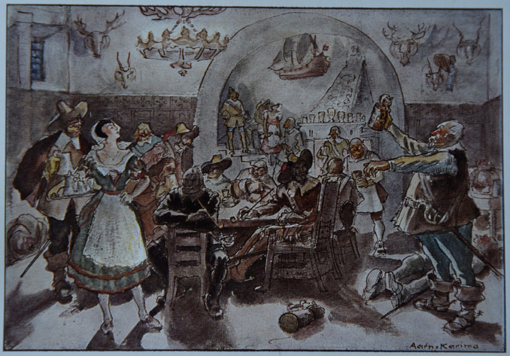
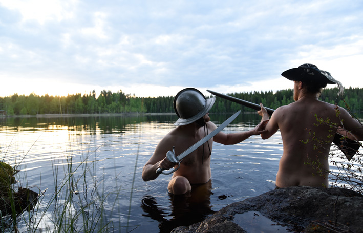
GARSin kolmatta vuosijuhlaa vietettiin retken ja iltajuhlan merkeissä lauantaina 11.11.2017. Kekkeripäiväksi valikoitui Kustaa Aadolfin päivästä (6.11.) seuraava lauantai. Tänä vuonna olikin erityistä syytä juhlaan, sillä olimme juuri palanneet menestyksekkäästi ryhmän tähän asti suurimmalta ulkomaanretkeltä De Slag om Grollesta 1627. Aloitimme juhlat ottamalla teemaan sopivan ryhmäkuvan:

Iltajuhlat aloitettiin kuvituksellisissa tunnelmissa. Kuva (c) GARS 2017.

Ryhmäpotretin esikuvateos ei tule tällä kertaa 1630- luvulta vaan 1930-luvulta: Aarno Karimon Upseerikemut 30-vuotisen sodan aikaan, vuodelta 1931 oli mielestämme tunnelmaltaan hulvaton kuva-aihe GARSin vuosijuhlille, siitäkin huolimatta, että kuva kertoo paljon 1900-luvun alun historiakäsityksistä ja todennäköisesti hieman vähemmän 1600-luvun alun kulttuurista. Suomessa on säilynyt harmillisesti vain melko vähän 1600-luvun kuvalähteitä, mutta halusimme silti versioida GARSin teemaan sopivan historiallisen juhlakuvan.

Ryhmäpotretin esikuvateos: Aarno Karimo, Upseerikemut 30-vuotisen sodan aikaan, ilmestynyt Kumpujen yöstä -sarjassa vuonna 1931.

Aarno Karimon  kirjoittaman ja kuvittaman, aikanaan suositun Kumpujen yöstä -teossarjan vaikutuksista suomalaisten historiakäsityksiin voisi kirjoittaa laajemmin erikseen. Tässä todettakoon vain, että GARS pyrkii elävöityksessään tuomaan esille pääasiassa tuoreempia historiantulkintoja. Kohtaamme esiintyessämme paljon erilaisia käsityksiä 1600-luvun ilmiöistä ja toisinaan saamme sellaisiakin kommentteja, joissa voi kuulla kaikuja Kumpujen yöstä. Karimon kriittinen kommentointi on siis ilmeisesti yhä toisinaan ajankohtaista.

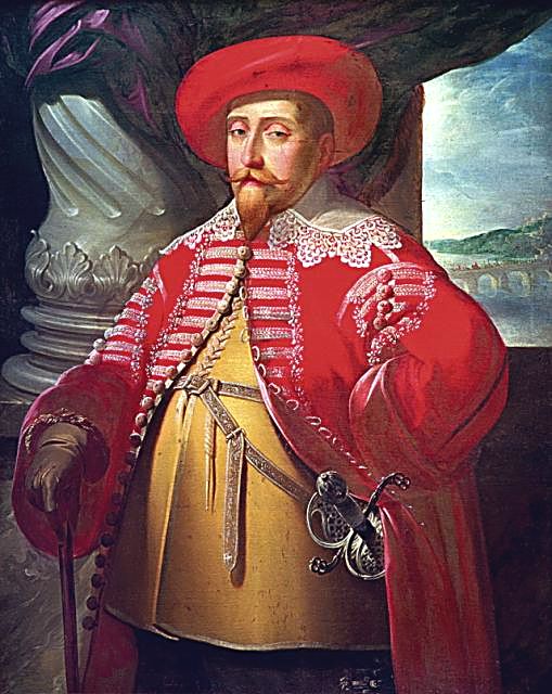
Hyvää Kustaa II Aadolfin päivää!

Tänään GARS täyttää kolme vuotta ja juhlan kunniaksi haluamme jakaa kanssanne Matthaeus Merianin vuonna 1632 maalaaman muotokuvan kuningas Kustaa II Aadolfista punaisessa puolalaistyylisessä takissaan.

Kustaa II Aadolf kävi 1620-luvulla kovasti sotimassa Puolassa, mutta GARS ei ole vielä ennättänyt elävöittämään näitä kahinoita. Toivottavasti pääsemme tulevaisuudessa paikkaamaan tätä puutetta jossakin mainiossa tapahtumassa Puolassa!

GARS toivottaa hyvää Kustaa II Aadolfin päivää!

Happy Gustavus Adolphus Day!